http://www.youtube.com/watch?v=i-Q8nSEeUec
Tiré du site pilotsfor911truth.org
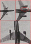
Le "flight path" est pas le même entre la réalité et la version "officielle"? Hmmm, ça rend ton 100% pas mal douteux mon Denis. Pauvre toi...
Pas d'avion au pentagone?
-
Laurent_Outang

- Messages : 507
- Inscription : 03 sept. 2006, 17:29
Si ton "flight path" croise le "flight path" du pompier...je compte sur toi pour...géranium a écrit :Le "flight path" est pas le même entre la réalité et la version "officielle"? Hmmm, ça rend ton 100% pas mal douteux mon Denis. Pauvre toi...
Je n'insiste pas...
He who thinks by the inch and talks by the yard deserves to be kicked by the foot. (Proverbe chinois)


Imprécis mais pas totalement dans le champ.
Salut Petrov,
Tu dis :
Pas du tout.Le "flight path" est pas le même entre la réalité et la version "officielle"? Hmmm, ça rend ton 100% pas mal douteux mon Denis. Pauvre toi...
Si l'animation~reconstitution fait éviter les lampadaires de l'autoroute, tout ce que ça démontre, c'est que l'animation~reconstitution est imprécise. Rien d'autre.
En passant, on ne voit pas le Cruise dans cette reconstitution. Elle n'est donc pas totalement incorrecte.
Les meilleures sorties de route sont celles qui font le moins de tonneaux.
Complément d'information:
http://pilotsfor911truth.org/pentagon.html
Questions for the US Govt regarding AA77 Flight Data Recorder.
1. The current FDR shows 480' MSL True Altitude, too high to hit the light poles. What are your findings of True Altitude at end of data recording 09:37:44. Why did you provide a Flight Data Recorder that shows the aircraft too high without a side letter of explanation? How did you come to your conclusion.
2. What is the vertical speed at end of data recording :44. How did you come to your conclusion.
3. What is the Absolute Altitude and end of data recording? How did you come to your conclusion.
4. Why does the csv file show the altimeter being set in the baro cor column on the descent through FL180, but the animation altimeter does not show it being set?(This is a blatent cover-up to confuse the average layman in hopes no one would adjust for local pressure to get True Altitude. Too bad for them we caught it).
5. Why do the current G Forces for the last minute of data correspond to the changes in vertical speed, yet at end of data :44-:45 it shows an increase in vertical speed never accounting for any type of level off to be level with the lawn as shown in the DoD video?
6. Do you have any video showing a clear impact and/or of the plane on its approach to impact?
7. Why does your animation show a flight path north of the reported flight path?
8. Why are there no system indication of any impact with any object up to and after :44?
9. Why does the csv file and animation show a right bank when the official report requires a left bank to be consistent with physical damage to the generator?
10. How did you come to the conclusion of 09:37:45 as the official impact time?
11. What is the exact chain of custody of the FDR? What date/time was it found? Where exactly was it found? Please provide documentation and names.
12. Why does the hijack timeline show a 3 min interval for hijacking to take place? Why did Capt Burlingame not follow protocol for the Common Strategy prior to 9/11?
-
Laurent_Outang
- Messages : 507
- Inscription : 03 sept. 2006, 17:29
L'instrument approprié.
Salut Petrov,
Je ne sais pas si les réponses sont connues pour toutes ces questions.
Quand une reconstitution est imprécise, on ne sait pas souvent pourquoi. Si on le savait, on la corrigerait. Non?
J'espère que les réponses qui vous seront peut-être données un jour vous satisferont.
Mais je n'y compte pas trop.
Les meilleures sorties de route sont celles qui font le moins de tonneaux.


Qui est en ligne ?
Utilisateurs parcourant ce forum : Aucun utilisateur inscrit